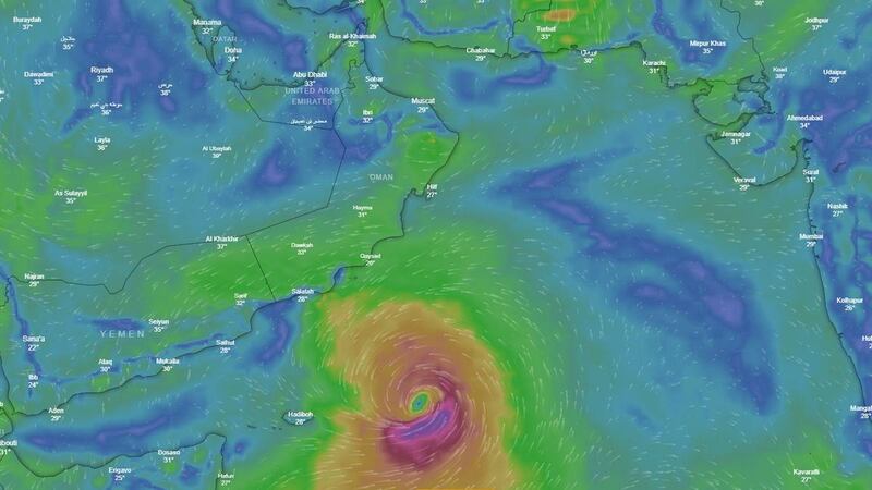

Forecasters say it is too early to determine the impact of a huge cyclone developing in the Arabian Sea but that it is expected to hit Oman in the coming days.
Although the UAE is not expected to be affected directly by the storm, experts said it could play havoc with weather systems here.
High winds and heavy rains are expected to hit Oman, but the UAE could experience high humidity and more fog as a result, the National Centre of Meteorology said.
The storm is not yet classified, so meteorologists are unsure how damaging it could become if it makes landfall.
“Although there is unlikely to be a direct effect from the cyclone on the UAE, we will be keeping a close eye on it,” said Mohammed Alebri, director of meteorology at the weather centre.
“Until now, all the numerical weather predictions are not giving us an exact reading, so this storm has not yet been classified.
“We are on a 24/7 watch to see how the storm may develop and following any changes in direction.
“There is usually a lot of rain as well as high winds but once it reaches land the storm should decay.
“The potential for damage is unclear at this stage as we are not yet sure of the strength of the cyclone, or what category it will be.”
A category one tropical cyclone can cause damage to crops and trees, with gale force winds and typical gusts over exposed areas up to 125kph.
Storms are graded in terms of their strength up to level five, which is the most destructive cyclone level and the most dangerous.
Typical gusts can be expected to reach 280kph, the highest grade of hurricane force winds.
Since 1945, the region has experienced 67 similar cyclones in the Arabian Sea, most in October and November.
Tropical depressions develop when the surface temperature of the sea is high, warming the air above it.
As wind speeds increase over the body of water, mass warming causes the air to expand and travel upward and outward, creating a column of wind with speeds of up to 62kph.
The effects can be devastating if the cyclone hits land.
“From experience, we know cyclones can change track,” Mr Alebri said.
“Once we are more aware of its formation, within 48 hours, we will have more of an idea of how strong it will be and exactly if it will make landfall.
“The cyclone is huge, so it could have an impact on the weather we see here, with more humidity for example.”
__________________________
Read more:
UAE forecasters warn of tropical depression in Arabian Sea
UAE Weather: Sweatember gives way to fog-tober as humidity soars and mist rolls in