DUBAI // Stunning photographs of Dubai taken from space, showing the staggering pace of urbanisation over the past 11 years, have become an online hit.
Hundreds of thousands of people have viewed the time-lapse videos and images taken by Nasa, documenting the creation of The Palm and The World islands.
There are 12 photographs dated between November 11, 2000 and April 25 last year showing the city's remarkable growth in that time.
They can be found on Nasa's Earth Observatory website. Slideshow videos of the images have so far attracted more than 240,000 views on YouTube from people all over the world.
"To expand the possibilities for beachfront tourist development, Dubai, part of the United Arab Emirates, undertook a massive engineering project to create hundreds of artificial islands along its Persian Gulf coastline," says Nasa's website.
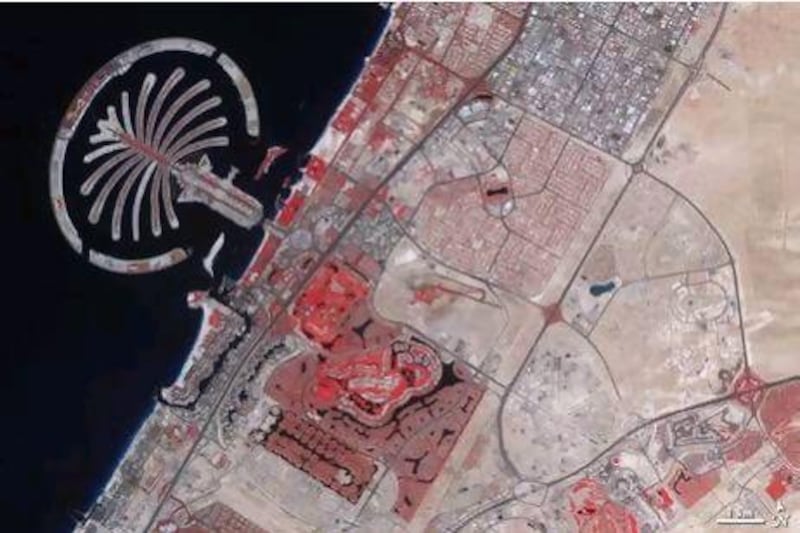
The pictures show how dredging helped to raise The Palm Jumeirah from faint outlines in 2002 to the complete structure, including buildings, by 2009.
"By October 2002, substantial progress had been made on The Palm with many sandy 'palm fronds' inside a circular breakwater," says the Nasa website.
"The final image, taken in February 2011, shows vegetation on most of the fronds and numerous buildings on the tree trunk."
At the same time Dubai can be seen growing out of the desert.
What look like thin lines begin to appear from February 2, 2002, with snake-shaped patterns popping up soon after. These eventually become the man-made lakes in Emirates Hills and Jumeirah Islands.
By November 4, 2003, road grids can be seen with more buildings being constructed. Dubai Marina, Media City and Internet City, The Greens and Tecom all begin to take shape.
The World islands begin to develop from 2004 and are fully formed by 2009.
"Inland, changes are just as dramatic between November 2000 and February 2011. In the earliest image, empty desert fills the lower right quadrant of the image, as cityscape primarily hugs the coast," the website explains.
"As the years pass, urbanisation spreads and the final image shows the area almost entirely filled by roads, buildings and irrigated land."
The pictures were taken by Nasa's Advanced Spaceborne Thermal Emission and Reflection Radiometer, or Aster, on the space agency's Terra satellite.
Nasa says the images are false colour, meaning bare ground appears brown and vegetation shows up as red, water is dark blue and buildings and paved surfaces are light blue or grey.
The images have delighted those who have seen them, with many commenting on social media.
"Beautiful! Nasa captures Dubai's insane 11-year urbanisation," tweeted Hamna.
"Wow! Dubai has seriously grown in 11 years. Check out the images," said Bearbledeals.
Thomas Brunskill tweeted: "So awesome! Artificial islands, parks, and new city blocks transformed Dubai over the past decade."
"Time lapse of epic proportions. Eleven years of Dubai's insane growth seen from space," tweeted mohamedsomji.
"Think Dubai's artificial islands look crazy? Just wait until you see them from space," said mariusmele.
There are at least three videos on YouTube featuring a short 44-second compilation of the images.
So far they have been viewed a combined 241,820 times.
The Terra satellite was launched in December 1999 as part of Nasa's Earth Observing System.
Aster is a joint project between Nasa, the Japanese ministry of economy, trade and industry, and the Earth Remote Sensing Data Analysis Centre, also in Japan.
* See the collection here