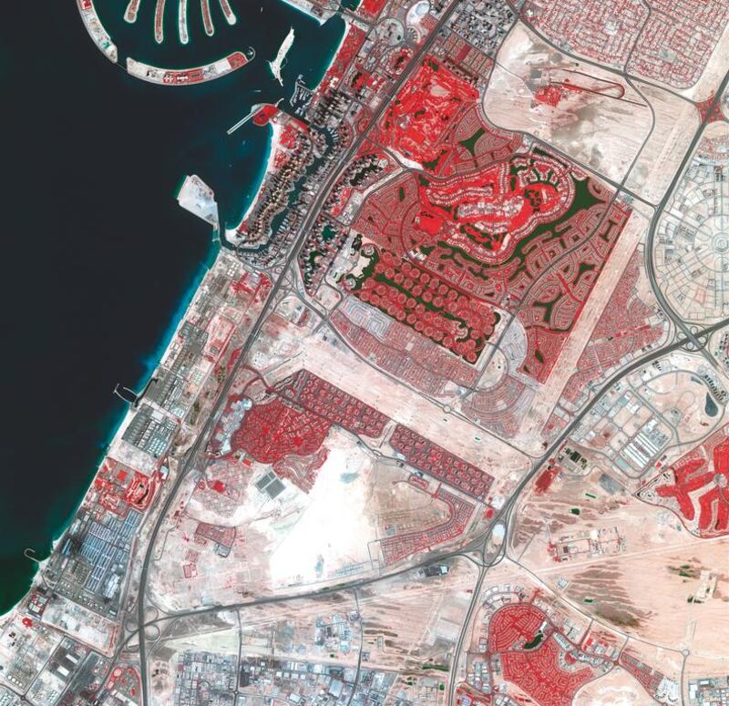
ABU DHABI // The greening of Dubai has been captured from space in a satellite photograph published this week.
Centred around Discovery Gardens, the image highlights the lusher communities in red, including Emirates Hills, Jumeirah Islands, and Emirates Golf Club and Springs.
Dubai Media Office on Saturday posted on Twitter the image that Dubai Sat-2 took last year.
The photograph uses false colours to represent certain types of areas. Vegetation is marked in red, bare ground is brown, water is dark blue, and buildings and paved surfaces are light blue or grey.
The image would be useful to public and private entities such as Dubai Municipality and environmental agencies, said Salem Al Marri, assistant director general of scientific and technology affairs at the Mohammed bin Rashid Space Centre.
As the satellite’s onboard camera was limited to capturing images that are 10 kilometres wide, it took five to six passes over Dubai to stitch together a complete picture of the city.
“The image you see is a mosaic which takes months to create,” said Mr Al Marri.
Even though Dubai Sat-2 circumnavigates the globe about 14 times a day, four of which are over the UAE, it takes more than three months to shoot Dubai in its entirety.
The duration will be significantly reduced when the UAE launches its next-generation satellite into orbit.
KhalifaSat, the first satellite built entirely by Emirati engineers, will augment Dubai Sat-2 when it is launched in 2018 and provide more detailed images thanks to a higher-resolution camera.
“If Dubai Sat-2 can tell you how many trees there are in a specific area, you will be able to identify what kind of trees they are with KhalifaSat,” said Mr Al Marri.
With a shelf life of about five years, KhalifaSat will be beaming images well after Dubai Sat-2 is decommissioned in 2020.
Dubai Sat-2’s infrared image is reminiscent of pictures taken of Dubai’s development by a Nasa satellite between 2000 and 2011. Using the same technology, Nasa’s Terra satellite took 12 photographs during that period.
Hundreds of thousands of people viewed the time-lapse video online, which documented the city’s remarkable growth and the creation of the Palm Jumeirah and the World islands.
tsubaihi@thenational.ae