First, you hear a thrilling roar as a huge body of water accelerates up a narrowing channel between two sheer walls of rock. Then, as it hits the closed end, there is juddering thump that you feel in your chest as much as in your ears, followed by a collapsing sigh as the deflated water backs out the way it came. Two minutes later it happens again.
This is the Gloup, one of the astonishing and savage delights of Orkney. The name comes from the Old Norse word gluppa, meaning chasm. The Gloup is a collapsed system of caves in the cliffs. Looking up from the Gloup, you are confronted by the Brough of Deerness, an almost-island accessible by a precarious and vertiginous footpath. The only sign of life on the Brough is the ruin of an early Christian monastery, which stares out from this most remote of places into the void beyond.
Call it Orkney. Not, the Orkneys, not, the Isles of Orkney, just Orkney. Got that? Visit Orkney and call it the Orkneys within hearing of the locals and I cannot guarantee your personal safety. Situated about 16km north of Dunnet Head, the northernmost point of mainland Britain, Orkney is a group of some 70 islands, 20 of them inhabited, home to just about 20,000 people. The largest island is - with magnificent bravado - called Mainland - mainland Britain being, in Orcadian eyes, hardly worthy of recognition.
Most of Orkney is low-lying. The exception is the large and sparsely populated island of Hoy, which boasts some of Britain's highest cliffs and a famous rock stack, the Old Man of Hoy, beloved of lunatics who climb it and eat picnics at the top. Every Orcadian mood is determined by sky, water and time. Oh, and wind. The winter wind in Orkney can literally blow you off your feet. On a "breezy" day, you open your car door cautiously: if the wind catches it, it will tear it from its hinges.
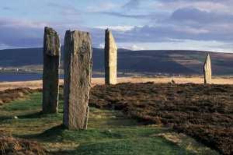
The abundance of daylight in summer is such that it is a tradition to go out at midnight on June 21 - the longest day of the year - to play a round of golf. The point is to complete the game before it gets dark. And you are never out of sight of water. The inlets and the lochs are everywhere. At Stenness, a narrow strip of land separates two lochs, Stenness and Harray. This is the site of the Ring of Brogar, a neolithic stone circle, the third-largest in the UK. Nearby is Maeshowe, one of Europe's finest prehistoric cairns, or tombs, measuring 35m in diameter and seven metres in height. The juxtaposition of these bodies of water and ancient centres of primitive religion lend Stenness an eerie and haunting beauty that is all its own. I caught a very small fish on Stenness Loch.
Each island has its distinct character. Rousay (population 212) is the fifth largest island in the group and is known as The Egypt of the North for its 100 archaeological sites. Chief of these is the broch of Midhowe, a huge dry-stone tower, part dwelling, part defence. From Midhowe you can gaze out at the absolutely terrifying current of Eynhallow Sound, which separates Rousay from Mainland. Turning inland, you are captivated by the sad and haunting sight of the numerous deserted and ruined farmhouses from which the tenants were forcibly displaced by landowners during the Highland Clearances in the 19th century to make way for profitable sheep. Memories are long in Orkney and these clearances have not been forgiven.
The islands of Lamb Holm, Glimps Holm, Burray and South Ronaldsay are joined to Mainland by the Churchill Barriers, a series of causeways created in the Second World War to block access to the natural harbour of Scapa Flow. Crossing them you see the masts of sunken ships - after the First World War, the Germans scuttled their captured fleet that had been held there rather than let the British have the ships.
Nearby is a bizarre baroque chapel built by Italian prisoners of war out of scrap metal during the Second World War. Climb Ward Hill in South Ronaldsay and you can see most of the islands and the Scottish mainland as well. A sign helpfully tells you how far it is to Melbourne, Australia. Back on Mainland, the Bay of Skaill is unmissable - one of Orkney's most beautiful places - in the distance you see the waves breaking on the headland - they seem to climb half the height of the cliffs. At one end of the bay is the Stone Age settlement of Skara Brae, at the other a simple wooden church from the 19th century.
Catch it on a sunny day and the great themes of Orkney - light, water and time - will meld into a moment that speaks of things eternal and will stay with you for life. That is, if the wind doesn't blow you half way back to Aberdeen.