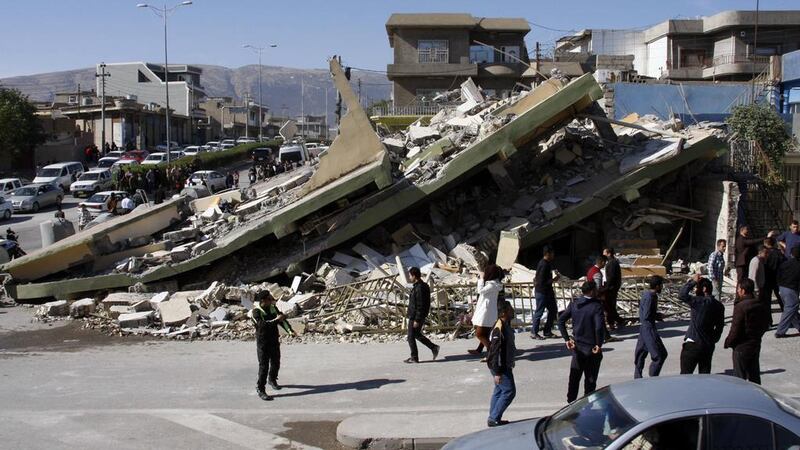
Last week’s earthquake in the Kurdish area of the Iran-Iraq border was a reminder of this region’s unstable ground.
Many of us will vividly remember the people running, terrified, and swept away by the inexorable waves of the December 26, 2004 tsunami in the Indian Ocean. With light shaking from last Sunday’s earthquake being felt in Kuwait and even the UAE, is the southern side of the Arabian Gulf immune to such disasters?
The recent earthquake struck in a relatively little populated area. Still, it was a powerful one with a magnitude of 7.3 on the Richter scale. More than 500 people are reported dead, as buildings collapsed in the Iranian province of Kermanshah and the Iraqi governorate of Halabja.
Casualties in such disasters do not depend only on the size of the quake. The tremor that levelled the historic city of Bam in eastern Iran in 2003 was smaller, with a 6.6 magnitude, but as many as 43,000 people may have died as buildings did not comply with seismic codes. Shoddy and corrupt construction under the former Iranian president Mahmoud Ahmadinejad’s housing schemes is being blamed for some of the latest casualties.
Iran and northern Iraq are vulnerable to such earthquakes. The Arabian tectonic plate, which includes the Arabian peninsula, the Arabian Gulf and Zagros mountains, is moving north at 2 to 2.5 centimetres per year, and colliding with the plates of central Iran and Turkey. As well as pushing up the mountain ranges, this leads to tremors as fault blocks slide jerkily over or past each other.
These tectonic movements have repeatedly brought tragedy in the past. They have also bought wealth, as the domed anticline structures created in the mountains are among the most prolific traps for oil and gas in the world. The small-scale fractures created in the brittle rocks are conduits for that petroleum to flow to wells and be extracted.
These quakes are felt in the southern Gulf region: in July 2010, and April 2013, Iranian earthquakes rattled the UAE. The country itself experiences small tremors, usually in the northern emirates. But large earthquakes in the stable crust of the Arabian Peninsula are rare, and there would seem no reason to worry about them.
This optimism could be misplaced, according to recent research from Camilla Penney of the University of Cambridge. As well as the collision along the Zagros, the crust of the Indian Ocean is diving below southern Iran and Pakistan along the coastal Makran mountains, at what is known as a subduction zone. In 1945, a large, 8.1 magnitude quake off western Pakistan caused a tsunami which struck the coasts of Oman and Pakistan and damaged the port of Gwadar.
Deaths were put at between 300 and 4,000, an indication of the imprecision of contemporary records. “The ground shook violently. One of the waves was huge … it was even higher than the minaret of the mosque,” recalled Amina, now more than 100 years old, who lived in Gwadar at the time when it was under Omani administration.
_____________
Read more:
Anger in Iran after earthquake flattens Ahmadinejad housing projects
Shifting Arabian plates mean tragic disasters are all too frequent for Middle East
_____________
A smaller tremor struck off the Pakistani town of Pasni this February but there are currently few earthquakes along the plate boundary in the western, Iranian Makran. Either stress is being released steadily, or it is building up to a devastating quake over a long period. German researchers have identified boulders along the Omani coast, up to 40 tonnes in weight and 6 to 10 metres above sea-level, which may have been washed up by tsunamis in the last 5,000 years.
A similar tsunami to that of 1945 would be far more devastating today. It probably would not affect the shallow Gulf, but it would hit the UAE’s east coast. Karachi has a population of 24 million, 1.3 million people live in and around Muscat, and several hundred thousand in Khor Fakkan, Kalba and Fujairah, most close to the shore and just a few metres above sea level.
Critical infrastructure is exposed, too: Gwadar’s port has now been greatly expanded with Chinese investment. The major port of Fujairah, exit for much of Abu Dhabi’s oil exports and one of the world’s key petroleum storage nodes, the Sohar refinery and petrochemical facilities, the Sur liquefied natural gas plant, Pakistan’s LNG import terminals, and a swathe of power and desalination plants – of necessity sited on the sea – could be vulnerable.
Tsunamis travel at 800kph in the open ocean, as fast as a jet airliner, slowing to 80kph in shallow water. The wave from a Makran quake might arrive at Muscat within half an hour, putting a premium on a quick response.
In 2013, Oman installed tsunami warning systems that measure sea level. The UAE has earthquake monitoring stations and building codes that proof against moderate seismic activity. Iran is using GPS stations to monitor the shortening of the crust and see where stress is building up. In 2014, a UN-organised event tested tsunami awareness around the Indian Ocean, including a possible simulated earthquake in the Makran.
There is no need to worry unduly. But some sensible planning for early warning and resilience is appropriate.
And, in a region where political tensions overshadow geological ones, this is one opportunity for positive international cooperation.
Robin M Mills is CEO of Qamar Energy, and author of The Myth of the Oil Crisis