Jerusalem is a city divided, but you wouldn't know it from the transport system. Since Israel annexed the city after the 1967 Arab-Israeli War, the government has employed various forms of urban planning and architectural practice to ensure that its control will never be ceded. Simple urban planning initiatives solidify Israel's grip on the city to create permanent facts on the ground.
The approach has worked, and the new Jerusalem light-rail transit network is a case in point.Under the hawkish leadership of mayor Nir Barakat, the Jerusalem light-rail network, outfitted with special rock-resistant glass that protects against infrequent rock throwing attacks by Palestinian youths, began gliding through the streets of the holy city in late 2011.
From Mount Herzl, where the father of political Zionism Theodor Herzl is buried, to Beit Hanina, a large Palestinian neighbourhood perched in the eastern ridges of the city, the light-rail network has impossibly blurred the political lines between East and West Jerusalem. There are no indications of borders when you ride the light rail. East Jerusalem, the location of a Palestinian capital according to the Oslo Accords, is nothing but another neighbourhood. Train lines have an uncanny ability to physically bind places together; when Turkey invaded Cyprus in 1974, many of the national train lines that connected the island were destroyed. They have yet to be rebuilt.
The largest public infrastructure initiative in the history of Jerusalem, the light-rail project took more than 20 years to complete.
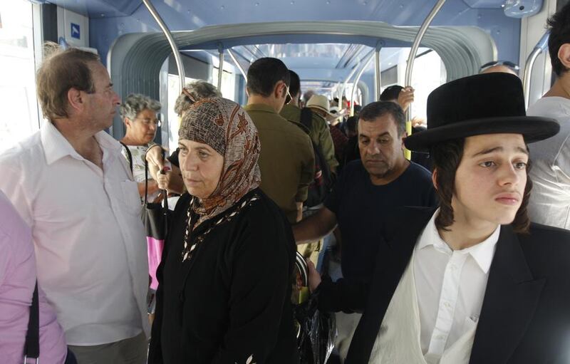
One recent day, as the mid-summer sun beat down on the golden walls of the Old City, the tram platform outside of the Damascus Gate station was busy with an eclectic mix of tourists, Palestinians and Orthodox Jews. As if in suspended animation, members of Jerusalem's multi-faceted tapestry of ethnic groups could all be found quietly making their way around the city on the tram. Announcements are made in a combination of Arabic, Hebrew and English, while an equal mix of the languages can be heard in the spacious tramcars. The light rail cuts a straight line through some of the most contested neighbourhoods in Jerusalem. An Israeli settler living in the mega-settlement of Pisgat Zeev, on Jerusalem's eastern flank, can pop on the light rail and be in downtown West Jerusalem in 20 minutes for the cost of about US$1.75 (Dh6). Never before have Israeli settlers in East Jerusalem experienced such ease of travel to the western part of the city.
Likewise, Palestinians have embraced the light rail, albeit for strictly practical reasons. With a station at the Damascus Gate of the Old City – the heart of Palestinian East Jerusalem – people living in distant neighbourhoods have incorporated the light rail into their daily commute.
But not everyone thinks the light rail is a good thing for Jerusalem. Many of the Israeli security guards that patrol all of the tram stations, wearing oversized tan collared shirts that barely conceal the firearms they carry, see the tram line as unnatural.
"The light rail is a disaster. If there is a technical problem, the entire city shuts down," says David, a security guard at the Damascus Gate tram station. In between quick updates in Hebrew through a walkie-talkie to other guards, he continues: "The real problem is the mixing of Palestinians and Israelis. Before the tram, Palestinians would take their buses and Israelis would take theirs. It was more natural."
Israel's use of urban planning and architectural practice to entrench its control over Jerusalem and the entirety of the West Bank has been defined by one goal – the siphoning off of as much Palestinian land as possible. The more settlements and light rails the country builds, the more a two-state solution to solve the conflict becomes impossible.
The ultimate by-product of this insatiable desire for land is total control and responsibility over all the Palestinians who live between the Mediterranean Sea and Jordan river. Regardless of the inevitable solution that will end the conflict between Israel and the Palestinians, the legacy of urban planning will be one of the most difficult to mend.
===
When US Secretary of State John Kerry announced in July 2013 the resumption of Israeli-Palestinian peace talks after a three-year absence, he was not thinking about the Jerusalem light rail. He was likely not thinking about the legacy of Israel's use of architecture and urban planning in entrenching the conflict he has been tasked to solve. From "separation walls" to "barriers" to "road blocks" and "sterile areas", Israel's occupation is defined by architecture.
The picture is radical in its simplicity. Palestinians have been corralled into small urban areas and given nominal security control to the Palestinian Authority. The majority of the West Bank, however, falls under Israeli military and civilian control. Israeli settlements of varying sizes encircle Palestinian urban areas while Palestinian villages close to Israeli settlements have been subject to a campaign of intimidation, whether through physical violence or the use of draconian legal measures aimed at driving the villagers off their land and into urban areas. Walls, barriers and checkpoints ensure movement is strictly controlled by the Israeli military.
The basis for this system of control is the Oslo Accords. Signed between Israel and the Palestine Liberation Organisation 20 years ago this week, the agreement gave way to interim self-government called the Palestinian Authority and divided the landlocked West Bank into three sectors: Areas A, B and C. With various restrictions, Palestinians were given control over Area A, or about 18 per cent of the West Bank's 5,628 square kilometres. The rest of the West Bank came under shared Israeli-Palestinian control or sole Israeli control, with 61 per cent falling into the latter category. Today, more than half of West Bank Palestinians live on the 18 per cent of land controlled by Palestinian officials.
Jerusalem, the centre point of Palestinian national identity, has been all but cut off from the West Bank. The city, slated to be a shared capital, according to the Oslo parameters, has been annexed to Israel and encircled by a ring of Israeli settlements, checkpoints and walls. The light rail is the latest measure designed to ensure Israeli spatial control through transportation.
The most recognised symbol of Israel's conquest of the West Bank – the Separation Wall – is also one of the most profound examples of the country's divide and rule policies. Building began in 2002 but the idea to create such a barrier, which is effectively a sober architectural monument to modernity, failed policy and conflict, was long standing in the Israeli military planning apparatus. Only the violence of the Second Intifada, in 2003, gave military planners the political clout to throw the planning idea into motion.
===
"The Israelis are creating a South African situation on the West Bank," says George Khalif, a Palestinian businessman in Ramallah. Sitting in a crowded cafe in the centre of Ramallah, Khalif echoes an increasingly popular sentiment on the Palestinian West Bank. Namely, that Israel no longer wants the two-state solution because Israel is unable to relinquish control over Palestinian land and the large network of settlements that is has created.
"They don't want to separate themselves from us Palestinians, but they don't want to include us as equal citizens in their country."
During the apartheid regime in South Africa, the government used urban planning to ensure separation of the races while retaining ultimate control over the population. Blacks were moved into townships that were located next to major cities, while whites were given the best land in the best locations. The system was meant to protect South Africa's reliance on cheap African labour while safeguarding separation of the races. Thanks to an elaborate permit system, populations were strictly monitored and controlled while curfews were enforced for blacks in white areas. The goal of this planning scheme was an inclusive form of separation, the availability of black labour and the complete dominance of the regime to control the entire population.
"Through a combination of brute force, dispossession and expropriation, and the imposition of negative laws and sanction the right of blacks to live in the city were constantly under threat, if not denied in full," notes the Cameroonian philosopher Achille Mbembe on the history of urbanisation in South Africa in Cityscapes, a journal published by the University of Cape Town.
The situation in Israel and Palestine is different from that which existed during apartheid in South Africa, but the right to live in the city, or any place of one's choosing, is equally under attack in both contexts through the use of similar practices.
If you jump on a Palestinian bus in East Jerusalem destined for Ramallah, the administrative capital of the Palestinian Authority in the West Bank, the similarities slap you in the face.
Leaving the smooth concrete motorways of Jerusalem, the bus twists and turns through the neglected streets of Palestinian neighbourhoods in the forgotten corners of the city. Trash overflows due to the near-complete refusal of the city to provide services to Palestinians. Then the bus crosses the infamous walls of the Qalandia checkpoint, the barrier that separates Ramallah from Jerusalem. The Israeli military is ever present; able to detain anyone they wish at will. There is no civilian law, and the military is the ultimate sovereign force.
Once past the wall, Ramallah is a sprawling mountain city where jumbled architecture clings to hillsides and many buildings are left unfinished. When you look to the horizon, Israeli settlements sit on top of various mountaintops surrounding the city. In these days of relative calm, movement between Ramallah and other towns is relatively easy, but the military checkpoints can be erected at any moment. Just as in South Africa, the regime has ultimate control to decide when people move and where they move to.
===
Despite the creation of one Israeli governing regime in the West Bank, one Jerusalem-based architecture firm is using architecture and design to open up possibilities for unravelling Israel's matrix of control in the West Bank.
"The conflict between the Israelis and the Palestinians is based mainly on a territorial problem, and therefore architects must play a central role in finding its solution," architect Yehuda Greenfield-Gilat told me recently in a Jerusalem cafe. Together with fellow architect Karen Lee Bar-Sinai, they founded Saya (Saya stands for Studo Aya), in 2006.
The ZeZeZe Architecture Gallery in the newly renovated Tel Aviv port is hosting a major exhibition of Saya's work on the conflict. The exhibition is split into three parts across the large gallery. Early works on the diplomatic process of negotiating a two-state solution – Saya architects are quick to note that former Israeli Prime Minister Ehud Olmert used one of their renderings of a divided Jerusalem in peace talks with Palestinian Authority President Mohammed Abbas – show Saya's historical development as a serious design studio tackling one of the most complex spatial conflicts in the world.
The main part of the exhibition is devoted to a series of renderings of what a two-state solution would look like between Israel and Palestine. Working with the Daniel Abraham Centre for Middle East Peace, Saya produced an interactive project that allows users to manipulate land swaps and their effects on the ground. An in-depth model of Jerusalem, with various projections of border crossings and checkpoints, also forms a large portion of this section.
"One of the main contributions that we believe architects can have towards resolving the conflict is really showing how peace could and should look like," says Bar-Sinai during our meeting in Jerusalem. "I think what captures people's minds is when you show them a 3D rendering of how a border crossing might look like. You need to show them how Jerusalem can transform into a city of two capitals living side by side."
The final part of the Saya exhibition looks to the future with a variety of renderings of how Jerusalem will look as two cities. Drawing on an extensive colour palette and using clean lines, the renderings of Jerusalem are compelling and overly hopeful.
"The basis to our activity is ideological," says Greenfield-Gilat. "Which means that we do believe that the only viable solution to this conflict would be some sort of independence of Palestinians and a sovereign Palestinian state. Therefore the practice is driven from that basic assumption."
There is an undeniable sense of naiveté about Saya's visions for the future stemming from their staunch ideological motivations. The result is work that is visually stimulating but disconnected from the reality of the conflict.
===
While the Israeli architects at Saya cling to the idea that the two-state solution remains a possibility, Palestinian urban planners are taking a different approach.From design studios to Palestine's first planned city, a new discussion about urban planning and architecture is taking shape in Palestine. Shams-Ard (Earth and Sun in Arabic), a design studio in Ramallah, is looking to sustainable design as a way of creating urban practices that are free from Israeli control. Since Israel controls all borders and imports into the West Bank, the young designers are using recycled materials to make furniture and buildings. They are showing Palestinians how to limit their dependence on Israel.
This discussion could not come at a better time for Palestine. The urban situation on the West Bank, after 46 years of military occupation, has led to a number of serious problems. Chief among them is a deepening housing crisis in West Bank cities. As more and more Palestinians find themselves in built-up urban areas, there is less space for people to live.
Salim Tamari, director of the Institute for Palestine Studies and an adjunct professor of contemporary Arab Studies at Georgetown University, blames the impending crisis largely on the explosive growth of Israeli settlements. "The main issue in terms of urban development on the West Bank is that there is confinement," Tamari, an affable older man with bushy eyebrows, explained in his book-lined office in central Ramallah. Between sips of strong Turkish coffee, he explains Palestine's quixotic urban geography, shaped by nearly five decades of Israeli occupation and the Oslo peace accords.
Just 15 minutes north of Ramallah, perched atop a dusty mountain, Palestine's first planned city is already welcoming residents. Rawabi is an urban project funded handsomely by the government of Qatar with the approval of the Palestinian Authority. While some Palestinians believe that Rawabi resembles an Israeli settlement and deplore the project's reliance on Israel to import building materials, the city marks a major milestone in the history of Palestinian urban development.
"If the political environment improves, then you will see Rawabi two and three," Amir Dajani, the deputy managing director of Rawabi, said on a recent tour. "If the political environment deteriorates and it is in a state of limbo, then we may have to reconsider our plans and maybe slow down part of the construction. We are living for today's politics."
Perhaps the most profound realisation taking hold in Palestine is the push to move beyond the empty promises of separation between Israelis and Palestinians.
"One of the challenges," says Nora Akawi, a 27-year-old Palestinian architect who used to work with the Al Ma'mal Lab, a design studio in Jerusalem's Old City, "is that we don't have the ability to visualise the West Bank and Jerusalem without the divisions that already exist. I think that we need to, as planners, be able to reimagine [the built environment] and free ourselves from the geopolitical divisions that currently consume our land."
As planners, the reality of the situation on the West Bank points to prolonged Israeli control, which is entrenched by the day through the creation of new settlements and infrastructure required for their upkeep. As Akawi notes, the challenge is for planners to embrace this reality and move forward. Urban debates in post-apartheid South Africa are excellent roadmaps for this intellectual transition.
===
"A city and a future that is co-created is far more likely to be owned by everyday urban citizens than a city that is created independently of the people who live in it and serves the needs of a few," writes Camaren Peter, a lecturer at the University of Stellenbosch near Cape Town, in a recent issue of Cityscapes. Nearly 20 years since the democratic transition from apartheid in South Africa, the legacy of the regime?s urban planning continues to plague the country. In Cape Town, black townships remain separated from white areas by a myriad of coloured communities that give the city an urban blueprint still defined by race. Even natural gentrification waves have yet to challenge the racial geography of the city.
The defining urban struggle of post-apartheid South Africa, therefore, is the attempt by blacks to reconquer the right to be urban. In other words, the battle is the right to choose where to live and it is far from over. South Africa, despite its impressive advances towards equality and democracy, has yet to unravel the urban planning legacy of apartheid.
An influx of citizens to urban areas and subsequent informal urbanisation as a result of bad urban planning has placed additional stresses on the post-apartheid urban struggles unfolding in South Africa. An archipelago of sprawled and disconnected enclaves has remained strong in major South African cities such as Durban, Johannesburg and Cape Town.
In Israel and Palestine, similar archipelagos have come to define the landscape of the conflict. Strengthened by transit networks, either in Jerusalem with the light rail or in the West Bank through settler bypass roads, disconnected Palestinian enclaves are being swallowed up by an ever-increasing sea of Israeli control.
As peace talks get off to a bumpy start, the struggle of post-apartheid South Africa to heal its urban division provides a startling warning for Israelis and Palestinians. Finding a solution to the conflict might be the easy part; the difficulty is undoing the system of discrimination embodied in urban planning and architecture practice Israel continues to entrench.
Joseph Dana is a journalist based in Ramallah.
Urban planning: Israel’s secret weapon in dividing Jerusalem
As peace talks resume 20 years after the Oslo agreement, Joseph Dana assesses the ways in which urban planning has cemented Israeli control and how architects and designers on both sides of the Separation Wall are envisioning the future. ?
Editor's picks


More from The National