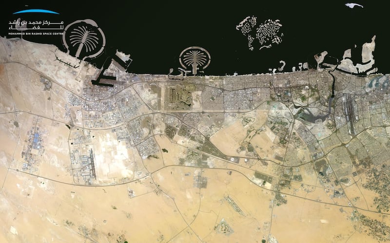

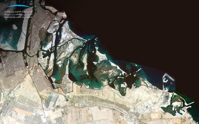
The Mohammed Bin Rashid Space Centre has released new high-resolution images of Abu Dhabi and Dubai, captured by KhalifaSat.
Research gathered by the satellite system has helped complete an updated map of the two emirates, which has been stitched together using many individual images.
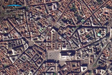
"The system captures a matrix of individual digital images to create a single high-resolution picture of the UAE's terrain," the MBRSC said. .
"This imaging system will provide a comprehensive view of the UAE’s topography, using remote sensing systems, image processing, geographic information systems and artificial intelligence."
So far, mosaic images of Abu Dhabi and Dubai have been released, but the MBRSC plans to release images of all seven emirates soon.
"The Mohammed Bin Rashid Space Centre seeks to contribute effectively to the community through projects that support the development sectors in the UAE," said Yousuf Hamad Al Shaibani, the centre's director general.
"The launch of KhalifaSat’s first satellite image mosaic is of strategic importance to support the infrastructure of all vital sectors in the UAE and promote strategic decisions by key stakeholders operating in the country."
How the mosaic images were created
The Mohammed Bin Rashid Space Centre says the KhalifaSat collected images of particular geographic areas over specific intervals, ranging from days or months. Those images are then combined to form one single comprehensive, high-resolution image.
"Mosaic differs from other satellite images as it has higher image resolution and clarity due to the use of the geo-referencing system and other modern technologies," a representative for the centre said.
“The mosaic imaging system at the Mohammed Bin Rashid Space Centre goes through systematic stages of image extraction," said Ammar Saif Al Muhairi, head of the centre's image-processing section.
"Firstly, individual images scattered over an area are taken by the satellite during a given period. The system then geo-assigns these images using a co-ordinate reference system to ensure the highest possible resolution.
"The image correction phase is followed by enhancing contrast and various corrections to make sure that all images are free of distortions. Finally, the colours of the satellite images are matched and blended, followed by the testing of the outcome by the relevant team, and ensuring its correctness before finally releasing it."